


Crag Alerts
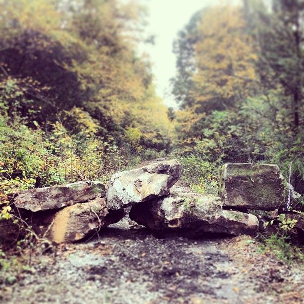 In late October, 2013, large boulders blocking the road appeared on Propp’s Ridge Rd and the old railroad grade that parallels the Meadow River on its south/west side. These boulders have effectively blocked vehicular access to the Meadow’s Southside Crags including Area 51, The Other Place, Orange Wall, Mud Hueco, Brilliant Pebble, Rehab Crag and the crags along Glade Creek, which parallels Propp’s Ridge Rd.
For NRAC, and locals, this came as no surprise. Land ownership along the Meadow and Glade Creek has been in a state of flux since long before climbers began to explore the Meadow River cliff line, which they did on foot, hiking in from Highway 19 along the railroad tracks which were still in place. It wasn’t until 1999 that the tracks were pulled up and climbers began to drive in and park along the Meadow River to access the climbing areas. For those around at the time, the easy access had a too-good-to-be-true feel to it, and losing it wasn’t an issue of if, but when.
Immediately after the roads were blocked, representatives from NRAC began discussions with land owners, the National Park Service, the County Commission, and others to explore options that would allow for continued access to the climbing resources along the Meadow River’s Southside crags.
What We Know:
Land ownership along the South side of the Meadow is a complex mish-mash of different stake holders that has been in a constant state of change. Simply determining who placed the boulders and who owned the different parcels of land was a challenge in its own right. After some research, Fayetteville climber and GIS specialist, Levi Rose, compiled a map (below) that offers some insight into the land ownership, as well as the location of the road blocks and the affected cliff line. The road blocks are indicated as red dots. There are three: one at the entrance to the railroad grade near Nallen, one along the railroad grade just downstream of the intersection with Propp’s Ridge Rd, and one that blocks both the trestle and the road over the top of the waterfall along Propp’s Ridge Rd.

The road blocks were placed by The Forestland Group, a timber investment management organization. They continue to manage the property, but have sold the mineral rights of nearly 11,000 acres, including the Propp’s Ridge access road, to a coal company called Xinergy Corp. Talks with the Forestland Group revealed that restricting vehicular access and recreational use was done at the request of their insurance company due to liability concerns. This closure is not directed specifically at climbers, but at all recreational user groups. Forestland Group has been continuously open and receptive to working with NRAC and has indicated that the potential for future recreational use on their land is a possibility. Currently, hiking, biking, and climbing on their property is considered trespassing and signs are clearly posted.
Later discussion with the County Commission revealed that the railroad grade along the Meadow River is part of a “Rails to Trails” land easement held by Greenbrier and Fayette Counties. This 2012 purchase was made possible with over $435,000 of grants secured for the project by the West Virginia Department of Highways and the National Park Service. More details on the acquisition of the Rails to Trails corridor can be read here.
What It Means For Climbers
Vehicular access to the Southside crags is quite likely gone for good. Hiking in from the road block at the waterfall on Propp’s Ridge Rd cuts directly through Forestland property and would be considered trespassing. The railroad grade that parallels the river, on the other hand, is completely open to hiking and biking along its entire length. However, stepping off the side of the road to hike, fish, or climb, throughout the portion upstream of the intersection with Propp’s Ridge Rd, would be considered trespassing. The land neighboring the railroad grade downstream of the road block near the intersection with Propp’s Ridge Rd. is not on Forestland property.
The cliffs located on Forestland property are: Rehab Crag (not included in any guidebook), High Density Feed Lot and Congo (2nd edition guidebook only), and Mud Hueco.
The Brilliant Pebble, Area 51, The Other Place, Hedrick’s Creek, and Orange Wall are not located on Forestland Property.
What To Do
Working with the Forestland Group and other land managers to find a legitimate and user-friendly access alternative will not be a quick and easy process. That said, we have faith that solutions to these challenges can be worked out. In the interim, we know that climbers are a resourceful bunch. If the climbing is good enough, climbers will find a way to get there. For now, the most legitimate way to access the crags along the South side of the river that are not on Forestland property is to park off of Dietz or Underwood Road as you would for the Lower and Upper Meadow. Hike down to the river, take your shoes off and get wet! Once on the other side of the river, Area 51 and the Other Place are about 2.5 miles upstream and Orange Wall is about 2 miles downstream. These areas are still within an easy and flat one hour hike of the car. It should go without saying that the Meadow River can be quite dangerous, or impossible, to cross at high water. Use your judgment!
Remember that YOU are the New River Alliance of Climbers. Our motto is “Get Involved, Be Informed, Stay Connected.” We’ll do our best to keep you updated on the evolving changes and we encourage everyone to stay informed and share the info with others. Please use your best judgment when accessing these areas and remember that your actions could affect our large community of climbers. Have fun out there!